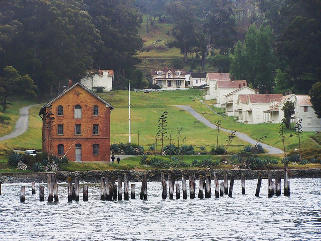
The Quartermaster Storehouse at Angel Island State Park’s Camp Reynolds is vulnerable to sea-level rise. Photo courtesy the Angel Island Conservancy.
Article By Aleta George
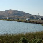
The late-19th-century whitewashed buildings at Angel Island State Park’s Camp Reynolds stand at attention on higher ground, but the old, brick Quartermaster Storehouse is nearly at water’s edge, and the waves from the bay are already eroding the seawall close to its feet. Although Angel Island is a fortress of steep metamorphic rock rising to 788 feet, the Quartermaster Storehouse (a popular destination for living history programs and overnight kayak trips) and Ayala Cove (the landing and concessions site for tourists) are vulnerable to sea-level rise, as are many shoreline portions of islands in the San Francisco Bay. From Bair Island in the South Bay to the Marin Islands off Point San Pedro, the islands of the bay will be affected by sea-level rise in different ways. Some may even be part of the solution.
There are different kinds of islands in the bay. The most iconic are the rocky ones, like recreational destinations Angel and Alcatraz, or those more frequently visited by birds than people, such as Brooks and Marin. There are marsh islands in the South Bay, like Bair and Greco, formed by sediment from streams that piled up until vegetation took hold to capture more sediment. There used to be many more of these until the spongy marshes ringing the bay were filled in and developed in the past century. There are also man-made islands like Treasure Island, a popular destination for cyclists and tourists who take selfies against the backdrop of the San Francisco skyline. And finally, there is Alameda Island, which actually wasn’t an island at all until the Oakland Inner Harbor Tidal Canal was dug and dredged to connect the Oakland Estuary with San Leandro Bay.
Projections about sea-level rise vary, but the California Ocean Protection Council estimates a one-foot increase by 2050, with the potential for a seven-foot increase by 2100.
Even though the exact amount of rise can’t be predicted, land managers and planners across the Bay Area are grappling with the scope of the problem. California State Parks has 128 units in the coastal zone, including Angel Island. “We have so many vulnerable facilities that we had to develop a system-wide approach,” said Jay Chamberlin, chief of CSP’s natural resource division. The agency has determined three options to adapt to sea-level rise: defend, accommodate, or retreat. Due to the cultural significance of Angel Island, however, the first priority is to document through photography or artifact retrieval the resources that will potentially be affected.
Beyond documenting, they don’t yet have any specific plans for Angel Island State Park, but Chamberlin believes that time will come. “Our sea-level rise strategy calls for a vulnerability assessment for each of our units with more robust planning. Those are obviously public discussions, and there’s going to be a lot of stakeholder engagement. You can go to Angel Island and see the entire metropolis of the Bay Area, and all those people are stakeholders who will be brought into the conversation.”
Those stakeholders can get a visual understanding of sea-level rise at Angel Island or other specific locations by using the Coastal Storm Modeling System (CoSMoS), an online tool provided by the United States Geological Survey and based on a model by the interagency partnership Our Coast, Our Future. CoSMoS provides a range of probable sea-level rise scenarios, and a map to show the effects. For example, with 19 inches of sea-level rise plugged into the map and a king tide thrown in for good measure, CoSMoS shows that the sea wall in front of Angel Island’s Quartermaster Storehouse would take more direct hits, and the road running along the water’s edge would be partially covered with water. Six feet of sea-level rise would overtop the sea wall and reach the building.
“There’s a range of potential futures, and it doesn’t stop rising in 2100 even though most models are only looking out to 2100. We have potentially hundreds of years of sea-level rise baked into our future at this point,” said Chamberlin.
Due north, West Marin Island near the mouth of San Rafael Creek is home to the largest egret and heron rookery in the San Francisco Bay Area. Up to 800 nesting pairs of great egrets, snowy egrets, great blue herons, and black-crowned night herons have been counted there. The Marin Islands National Wildlife Refuge and State Ecological Reserve includes West Marin and East Marin islands and a supporting swath of nearly 340 acres of submerged tidelands. “Those tidelands are a nice smorgasbord for the birds,” said biologist Meg Marriott.
Black oystercatchers nest on the sand and rock beaches of East Marin Island, only one of two places (along with Alcatraz) in the San Francisco Bay Area where the sensitive birds are known to nest. To the north, the beaches transition to a rocky intertidal zone and mudflats used by sandpipers, willets, black-necked stilts, pelicans, and cormorants.
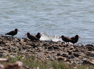
Black oystercatchers live on East Marin Island. Photo by Meg Marriott.
CoSMoS shows that 19 inches of sea-level rise would cover a portion of the beaches, and a four-foot rise would put most of the beaches underwater. With a six-foot rise, the water reaches the base of the steep, graywacke walls. In all of these scenarios the tidelands would flood, and thus change this important ecological food niche. Although the rookery habitat in the trees won’t be affected by sea-level rise, the bird’s food source would likely change. “Sea-level rise and warming of the oceans is almost certainly going to cause their prey to redistribute. If their prey is not coming into the area because it’s too warm, then they may leave the islands,” said Marriott. “There is really nothing that we can do to mitigate for sea-level rise since it’s a hard edge and we don’t really have any space to mitigate to,” she added.
Any statement about the scope of the problem is an understatement. “There’s a lot of work being done on risk assessment and understanding what the impacts will be,” said Brian Holt, East Bay Regional Park District’s chief of planning. “Frankly, when we start looking at possible solutions, it starts to get really complicated and expensive. The scale of the challenge is huge.”
EBRPD manages 50 miles of shoreline that is adjacent to development and the San Francisco Bay Trail, including on Alameda Island. Historically, Alameda had a large mature marsh that covered its northwest side, but it was filled with dredge material and built upon. The San Francisco Bay Trail runs along the southern shore of Alameda from the Bay Farm Island Bridge to Crown Memorial State Beach and Crab Cove Visitor Center, both operated by EBRPD. A look at sea-level rise scenarios at Alameda Island with CoSMoS reveals that 19 inches of sea-level rise would flood some portions of the Bay Trail at the southern end. With four feet of rise, parts of the Bay Trail and the beach are flooded, and in higher-range projections, the entire southern edge of Alameda is underwater.
Planning is underway for a new 170-acre park at Alameda Point, which was once home to a naval air station. In the designs, EBRPD has the opportunity to build in upland migration for rising sea levels. But a look at CoSMoS for Alameda Point (and for Treasure Island, which similarly expects new development on land made of fill) is sobering, and puts a point on the challenge of building up these properties to accommodate sea-level rise.
Marsh islands, such as Greco and Bair islands near Redwood City in the South Bay, are more resilient to sea-level rise. “We expect [these islands] will be able to keep pace with sea-level rise because they really are good at creating sediment and forming new marsh that keeps moving uphill, as long as sediment supplies stay the same,” said Dave Halsing, executive project manager of the South Bay Salt Pond Restoration Project.
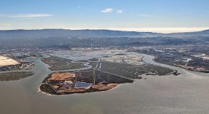
Bair Island is composed of three islands (Inner, Middle and Outer) totaling approximately 3,000 acres of former salt ponds. Photo by Dick Lyon, courtesy Wikimedia Commons.
Greco Island is a mature, natural marsh that supports endangered and threatened species. Northwest of Greco is Bair Island, which was historically a tidal salt marsh before it was diked for agriculture and then divided into three islands for salt evaporation. The island was saved by citizen groups and became part of the San Francisco National Wildlife Refuge. In a ten-year restoration project that began before the South Bay Salt Pond Restoration Project, they built up the soil and breached some of the outer levies so that tidal action could continue to build up the marsh’s interior.
The optimism that these tidal marshes will survive sea-level rise evaporates with the possibility that the water could rise faster than expected. “Our expectations of sea-level rise are adjusted by ongoing science, research, and modelling, and they almost never tell us it’s going to be slower or less severe than we think,” said Halsing.
Greco and Bair represent a story of connectivity. Southeast of Greco Island is Bedwell Bayfront Park, and east of that is the refuge’s Ravenswood Pond Complex. These connected open space marshes provide recreation and habitat for wildlife. They will also provide a buffer for U.S. Highway 101, Facebook headquarters, and wastewater treatment plants in the face of sea-level rise as well as storm and king tide events.
“Although ninety percent of the marsh habitat in the San Francisco estuary has been lost, there’s great opportunities to restore lands back to tidal marsh habitat all around the bay,” said Chris Barr, acting manager of the San Francisco Bay National Wildlife Refuge Complex.
Funds from 2016’s Measure AA are supporting many current wetland restoration projects, but EBRPD’s Holt hopes there will be more targeted money to deal with this issue. “[Most of] the funding right now is really towards infrastructure protection, and as far as what’s coming from the federal level, there’s not even that. Hopefully, times will change, and we’ll be able to have a big climate bond, or something along those lines, that can actually provide some meaningful investment.” With that investment, land managers can design projects that protect infrastructure and address habitat and recreation while building resilience to sea-level rise for both the mainland and the islands we love.
Aleta George covers open space for the Monitor.