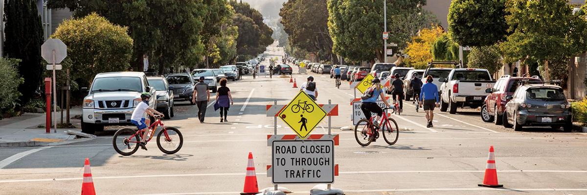
Slow streets programs in places like San Francisco have created new and safer walking and bicycling opportunities. Photo courtesy SFMTA.
Bay Area kids are biking without traffic interruption, pavement has become a gateway for social connection, and original art installations are addressing pandemic-related transportation challenges and inequities.
These are by-products originating from “slow streets” programs that began in at least a dozen Bay Area communities this spring. Signs, cones, and barricades are limiting car traffic and providing more space to safely walk, bike, and move as the coronavirus pandemic and social distancing guidelines heighten the need to be active outside.
For these reasons, slow streets programs have been generally well-received among Bay Area residents. But they aren’t without shortcomings, including complications regarding geographic equity and community outreach. Stakeholder engagement continues to be important as transportation officials — uncertain about vaccine timing and the eventual end to social distancing — consider whether slow streets programs will outlast the pandemic.
“We’re trying to evaluate what ‘permanent’ even looks like” and be transparent about the pathway there, said Warren Logan, policy director of mobility and interagency relations for the Mayor’s Office in Oakland.
Early on in the pandemic, the City of Oakland began a slow streets program, borrowing from its 2019 bike plan. That plan laid out a 74-mile network of neighborhood bike routes from which transportation officials have launched 21.4 miles of slow streets since mid-April.
Cities such as San Francisco and Redwood City soon followed Oakland during the spring, and newcomers may still get on board. City of San Jose officials are exploring street closures for pedestrian and bike-only use following approval of its “Better Bike Plan 2025.”
“We’re not first out of the gate but we’re making sure we’re learning the lessons [other cities] have to offer about how to implement a program,” said Jessica Zenk, deputy director of San Jose’s Department of Transportation.
The Monitor spoke with officials in the three early-adoption cities to see how recent activity is shaping slow street development.
Oakland
About 77 percent of Oakland residents said they support the slow streets program, based on a spring online survey. Data also points to a desire to extend the program after shelter-in-place restrictions ease, with residents in West, Downtown, and North Oakland communities expressing the most enthusiasm.
Since support can vary by demographics and geography, community groups have urged better engagement to understand why slow streets weren’t as successful in areas such as East Oakland.
City councilmember Loren Taylor, who represents East Oakland’s District 6, said slow streets are part of a broader set of solutions to help neighborhoods affected by traffic safety, crime, and violence. Ney Avenue, which became a slow street in late May, is in an area “that’s not hyper-receptive to bike lanes and other interventions that have been part of the increased pedestrian mobility effort,” Taylor said.
What city transportation officials also discovered is that a January hit-and-run accident that killed a mother on 98th Avenue continued to generate feelings of distrust about the city’s handling of traffic violence and the role of slow streets in improving the situation, according to Logan.
“While Slow Streets may not be a perfect program, we were then, and continue now, to pursue rapid, proactive solutions to streets we know are dangerous,” he said.
One solution to improve Oakland’s slow streets program is the “hardening” of materials in priority neighborhoods. Local artist Jonathan Brumfield, as part of a Smart Growth America initiative, has built and painted several sturdy barricade planters and signage that better harmonize with Oakland culture while still encouraging safe distancing. The first installment, unveiled in October, sits at the intersection of Plymouth Street and Auseon Avenue.
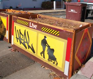
New barricade planters by artist Jonathan Brumfield were recently installed in Oakland. Photo by Alec MacDonald.
The Oakland Department of Transportation sign shop is using Brumfield’s artwork to develop aluminum signs that will be introduced in phase two of the program and rolled out on streets like Ney Avenue, according to Logan.
“We hope the combination will provide additional clarity about the program while reducing confusion associated with other construction in Oakland neighborhoods,” he said.
San Francisco
The San Francisco Municipal Transportation Agency (SFMTA) found about 78 percent of 6,500 residents support its slow streets program, based on an online questionnaire between April and September. However, staff felt that data wasn’t representative of the city as a whole, said Shannon Hake, SFMTA’s slow streets program manager. So they’re refocusing outreach on individual neighborhoods to determine the program’s future and its quality-of-life impact beyond the pandemic.
“We’re looking for a longer-term rationale for having slow streets,” Hake said. “So we’re looking back at the San Francisco general plan, which is supportive of streets like this. One of the things we want to make sure we do is really focus on neighborhood outreach along corridors that may be considered for future permanent changes.”
Feedback from the Glen Park Association (GPA), a San Francisco neighborhood group, shows pro-and-con aspects as experienced on Chenery Street, two blocks of which are closed to car traffic.
Nicholas Dewar, who lives on the 900 block of Chenery Street, said there’s been “no significant downside for us” and that it “really shifts the feel of our surroundings” to have kids playing, joggers out, and people chatting as they walk to Glen Canyon Park. But he’s noticing cars travel faster now compared to when the program started on Chenery Street in late May.
Bonnee Waldstein, GPA’s secretary, added that more drivers are using Chenery Street to cut through traffic and that she felt overall the two-block configuration is “not ideal and causes a lot of confusion.”
SFMTA hopes to resolve issues such as these gradually by communicating more with residents living on slow streets. Additionally, a big area of focus is making tweaks to slow streets signs and barricades, most of which were intended for short-term use and are vulnerable to wear, tear, and vandalism. Some residents have even taken it upon themselves to help, creating homemade signs and planters to reinforce safety.
Now, SFMTA is transitioning to the use of more durable materials, including flexible roadway delineators and posts, along slow streets corridors. They’re already in place on Page and Shotwell streets, Hake said. The move will help cut the agency’s maintenance and replacement costs.
Flexible treatments are supported by $1.175 million in Proposition K sales tax funding received from the San Francisco County Transportation Authority in September. This revenue stream will help SFMTA run its slow streets program for at least another year, Hake added.
Redwood City
On the Peninsula, Redwood City officials restricted vehicle access along 5.5 miles of roadway stretches to establish a slow streets pilot program that began May 1 in higher-density and lower-income neighborhoods with less access to outdoor space.
When asked when the pilot program should end, about 44 percent of residents said “never” and 16 percent said “immediately,” based on more than 200 responses from surveys distributed via social media ads and directly to people living on slow streets. The rest of responses were somewhere in the range of ending the pilot when either the weather turns cold, a vaccine is available, or shelter-in-place is lifted.
But some slow streets in Redwood City’s pilot program are earmarked as bike boulevards per its 2018 transportation plan. That could provide an avenue to transition to more permanent traffic-calming measures should the city council decide to extend the program, said Jessica Manzi, transportation manager.
“With bike boulevards we’re not restricting traffic, but they are designed in a way that people drive more slowly,” said Manzi, adding that these byways rely on a combination of features like traffic circles, speed bumps, and bulb outs.
Taking It Slow
The common denominator among many cities is that there is ongoing support for slow streets and cities are showing commitment to think creatively to keep programs going.
Oakland transportation officials are considering a “pop-up” approach that would, for example, provide residents flexibility to close their streets to vehicle traffic only on weekends.
“Maybe time is the variable we need to adjust versus geography,” Logan said.
Legislation also may prove a motivating factor for some cities. Recently passed Senate Bill 288 (Wiener) speeds up approval of sustainable transportation projects, including slow streets. That could provide cities who’ve been piloting slow streets projects an opportunity to make programs permanent as communities think about their use of public space.
“In a certain way, [SB 288] goes hand in hand with supporting this period of experimentation,” said Johnathan Kass, interim director at SPUR, a nonprofit planning group. “The CEQA review process can be burdensome and discouraging for doing really good and sustainable transportation projects.”
If anything, the pandemic has revealed wide-scale energy for walking and biking, interest that advocacy groups intend to harvest and spread to new areas.
“The demand is still there,” said Patrick Band, executive director of the Napa County Bicycle Coalition.
The group has proposed slow streets in the City of Napa where the Oak Knoll South automated bike and pedestrian counter recorded 21,082 users on the Napa Valley Vine Trail in August, up from 8,970 users the prior year.
Said Band: “Ridership and use of our existing bike and pedestrian corridors is as high as it’s ever been.”
Cecily O’Connor covers transportation for the Monitor.