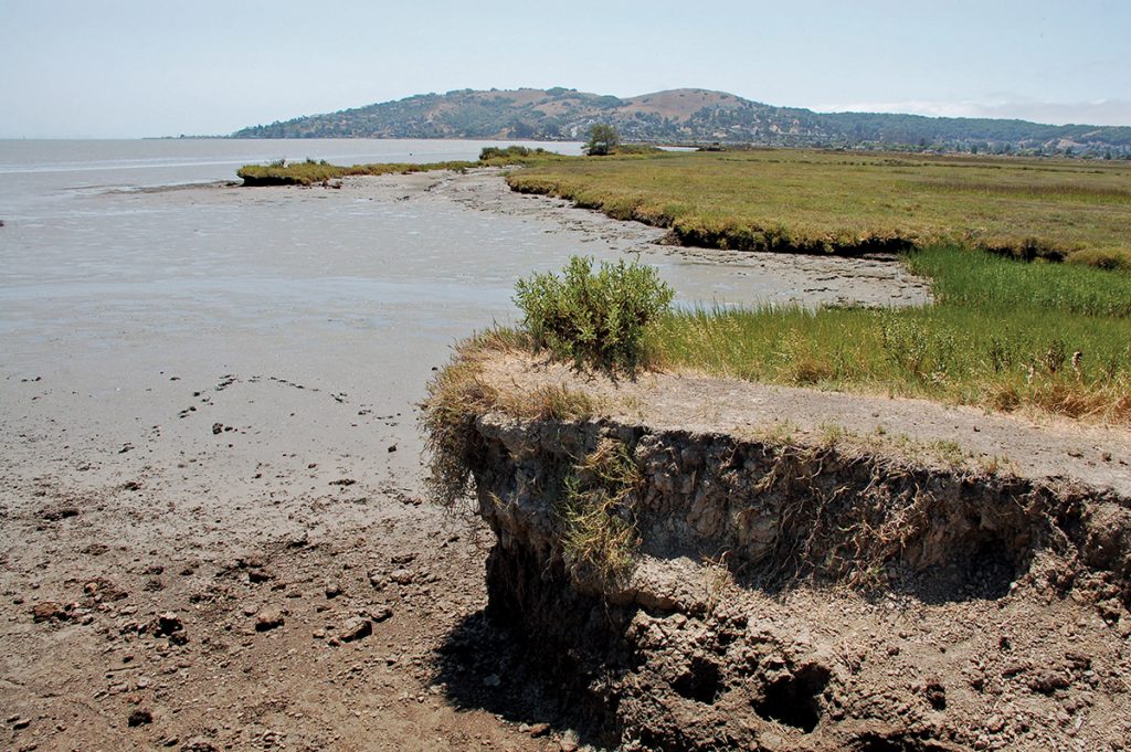
Eroded scarps along the bayward edge of Corte Madera Marsh illustrate how waves, limited sediment supplies, and rising sea levels can drive shoreline retreat. Photo by Alec MacDonald.
When Brenda Goeden first started working on mud, silt, and sand in the San Francisco Bay two decades ago, dredgers and contractors couldn’t get rid of all the sediment they excavated fast enough. “They’d dump it in the ocean because that was cheapest,” recalled Goeden, the Sediment Program Manager for the Bay Conservation and Development Commission (BCDC). But today sediment is a hot commodity, as restorationists and developers scramble to elevate salt marshes and building sites before rising tides claim them. Now, a new plan is in the works to optimize allocation of this critical resource.
“Sediment is huge,” said Christina Toms, an ecological engineer at the San Francisco Bay Regional Water Quality Control Board. “Without adequate sediment, tidal wetlands will drown.”
Salt marshes protect the bay shore from crashing storm waves, making these wetlands vital to preparing for sea level rise. “The bay used to be ringed by hundreds of thousands of acres of wetlands,” Toms continued. “But about 90 percent have been destroyed.” People began diking and filling the bay’s wetlands for agriculture and urban development in the 1800s. Then, 20 years ago, bay restorationists set a goal of rebuilding 100,000 acres of tidal marsh by 2030.
So far, so good — we’re about halfway there. The bay has been rich in sediment ever since the Gold Rush, when hydraulic mining eroded extensive swaths of the Sierra Nevada foothills. Winter rains washed the eroded hillsides into streams and rivers, which then carried the sediment across the Central Valley, through the Sacramento-San Joaquin Delta, and into the bay. Now, though, this extra sediment may finally be running out.
Will there still be enough to rebuild our marshes in time to keep pace with sea level rise? Restorationists aren’t entirely sure because getting a handle on sediment is tricky. Take it from none other than Albert Einstein, whose son Hans Albert Einstein was a UC Berkeley professor half a century ago studying sediment transport in rivers. When asked what he thought of his son’s career, the elder Einstein said, “He is working on a more difficult problem,” according to Walter Mih’s 2000 biography The Fascinating Life and Theory of Albert Einstein.
Tracking sediment in the bay is “very hard because it’s a big, complex system,” BCDC’s Goeden said. Sediment comes in from a range of sources besides the Sierra Nevada, including creeks that drain local watersheds as well as the ocean. Moreover, the amount of sediment coming in varies over time. “It’s affected by rainfall and how fast rivers are moving,” explained Jeremy Lowe, a San Francisco Estuary Institute (SFEI) scientist who has worked on tidal wetland restoration and sea level rise adaptation for 30 years. People muddy the sediment picture even further. “We dredge and move it around a lot,” he added. The key to keeping tabs on sediment — and the salt marshes it nurtures — is monitoring.
This spring marked the launch of an effort to establish tidal marsh monitoring all around the bay. “Right now monitoring is done project by project,” said the San Francisco Estuary Partnership’s Heidi Nutters, who is project manager of the new effort, which is fittingly called the Wetlands Regional Monitoring Program (WRMP). Other partners include SFEI, the San Francisco Bay Regional Water Quality Control Board, and the U.S. Environmental Protection Agency. “We need to close the gaps with a monitoring network throughout the region,” Nutters said.
Salt marshes tend to do well in the South Bay, where 15,000 acres of former commercial salt ponds are being restored to tidal wetlands. “A lot of sediment moves around in the South Bay,” the Water Board’s Toms explained. “There are very extensive mudflats so a lot of sediment gets resuspended in the water and rates of natural accretion are very high.” At the other end of the spectrum is Corte Madera Marsh in Marin County, which is eroding along its bay edge. “It’s kind of unzipping,” she said. “It’s converting to unvegetated mud flat and open water.” But the prospects for many marshes around the bay are unknown.
Marsh gains and losses can be measured by sticking metal plates upright in the mud, and seeing if the plates are buried deeper or become more exposed over time. In addition, the sediment supply can be assessed in a variety of ways. For example, flow gauges in a stream yield estimates of how much sediment is delivered from a particular watershed, while turbidity sensors yield estimates of how much sediment is suspended in the water at a given spot in the bay.
“The WRMP will build a picture of sediment in the bay and how it moves around,” SFEI’s Lowe said. “Do we have enough sediment in the right place at the right time?” More comprehensive monitoring will also reveal which tidal marshes are keeping up with sea level rise on their own and which ones need help most.
“Sediment is one of the biggest dials we can turn but it’s a limited resource and is very expensive to move around,” Toms said. “Voters are investing in restoration with Measure AA’s $25 million a year for 20 years — the WRMP will help us make decisions to get the biggest bang for the buck.”
The next step will be figuring out how to feed a sediment-starved marsh. Until now, actively rebuilding marsh has basically meant heaping sediment on former wetlands that were diked off for agriculture long ago and had subsided. The first of these was the Sonoma Baylands, 322 acres that were about six feet below sea level in the early 1990s. Filling that enormous depression took 2.8 million cubic yards of sediment dredged from the Petaluma River and Port of Oakland.
Saving an existing marsh from drowning will require considerably more finesse. “We can’t just put sediment directly on the marsh,” Lowe said. “It would fill the tidal channels and bury the plants.” The question is how to add sediment in a way that allows the marsh to live. While no one knows how to do that for sure, Lowe has some thoughts.
One possibility is putting dredged sediment in a barge and releasing it on a mudflat near the marsh. “Then we could let the waves carry it in just as they would naturally,” he said. Another is to tap the sediment that collects behind dams in local watersheds: “Could we build a big pipeline and slurry it down?” Lowe mused. However, he emphasized, for now these are just ideas on paper.
The sooner we figure out how to revitalize our tidal marshes the better. “We need to focus on the bay’s wetlands,” BCDC’s Goeden said. “The time is now for them.”
Robin Meadows covers water for the Monitor.