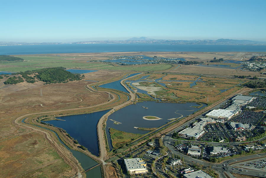
Novato Creek (the thin line of water snaking out from the bottom left side of the above photo) in eastern Marin County is one of three Bay Area creek systems to have gone through a visioning process for establishing a more natural interface with tidal baylands. Photo by Sue Lattanzio.
A new approach to flood management around the San Francisco Bay could trim maintenance costs for water agencies, restore habitat for endangered species, and help protect against rising seas. What links the three? Sediment.
Winter storms push sediment down creeks that flow into the Bay and, long ago, these waterways fanned out when they reached the edge. Sediment settled there, nourishing tidal baylands — salt marshes and mudflats that are rich in wildlife, and also buffer the shore from storm surges, the highest tides, and sea level rise.
Today few of these low-lying tidal baylands remain. Seeing them as useless swamps, people built levees around them so they could be drained for development. But levees also disconnect tidal baylands from the creeks that once fed them.
Creeks that are confined by levees no longer have room to move naturally, so they don’t spread out and build salt marshes along the edge of the Bay anymore. “Levees lock creeks in place,” said Scott Dusterhoff of the San Francisco Estuary Institute (SFEI), a Richmond-based nonprofit that provides independent scientific support on environmental issues. “Many of them flow straight out to the Bay.”
Now SFEI is working with stakeholders — including water agencies, regulators, and landowners — to find a common vision for reconnecting creeks with tidal baylands. “There’s a shift in the regulatory agencies,” Dusterhoff said. “The new thinking on flood control is to increase resilience by working with natural processes.” The time is right, he added, because much of the Bay Area’s flood control infrastructure was built in the 1950s and is nearing the end of its lifespan.
So far, three creek systems have gone through this visioning process: Walnut Creek, which flows into Suisun Bay; Novato Creek, which flows into San Pablo Bay; and Calabazas and San Tomas Aquino creeks, which merge and flow into the South Bay. Visioning was funded by the U.S. Environmental Protection Agency. And funds to help turn these visions into reality could come from Measure AA, which voters across the region’s nine counties collectively passed in 2016, and which will raise about $25 million a year over two decades for restoration projects in the Bay.
Walnut Creek
The Walnut Creek project is farthest along. The lower reaches of the creek were straightened to facilitate shipping but this also had other consequences. “For the last almost 60 years, the channel has filled in very quickly with sediment,” explained Paul Detjens, a civil engineer at the Contra Costa County Flood Control & Water Conservation District.
On the good side, this creates marsh inhabited by rare and endangered species, like black rails and salt marsh harvest mice. On the bad side, sediment in the channel impedes flood water conveyance and must be removed regularly. The district has dredged a total of about 1.4 million cubic yards of sediment from the channel since 1965, which lessens flooding but also renders the marsh habitat temporary.
Walnut Creek originally had room to move freely near its mouth, meandering through — and bringing sediment to — a floodplain up to three-quarters of a mile wide. “The creek used to squiggle but now levees separate it from the floodplain,” Detjens said. The district wants to reconnect the creek to its floodplain by moving the levees back about 500 feet. This was one of the visioning team’s recommendations, Detjens said, adding, “We benefitted greatly from the expertise assembled.”
Allowing nature to take its course will move sediment from the channel to the floodplain, cutting dredging costs and boosting sustainable marsh habitat. Moreover, a regular supply of sediment will help the marsh growth keep pace with sea level rise, bolstering flood protection in the future. “We are designing for the next 50 to 100 years,” Detjens said. Scheduled to begin construction in 2020, the project will restore the lower four miles of Walnut Creek and the district has requested Measure AA funds to help pay for the estimated $15 million cost.
Novato Creek
The tidal baylands around Novato Creek were diked off more than a century ago and converted to agriculture, primarily ranching. Today, the channel is choked with sediment. “You used to be able to sail schooners up it but now you’d be lucky to get a kayak up,” said Roger Leventhal, a flood control engineer with the Marin County Department of Public Works.
Moreover, draining the tidal marsh exposed the organics-rich peat to air, and the soil slowly decomposed. This led to a topsy-turvy landscape: the soil has subsided so much that the bottom of the creek, which is bounded by levees, can be several feet higher than the land around it.
Reconnecting Novato Creek with its former tidal baylands will help solve both problems. The department wants to start by breaching a levee in Deer Island, which is about three miles from the creek mouth near the intersection of highways 101 and 37. “We’ll punch a hole a couple hundred feet wide to let the water in,” Leventhal said. “The tides will come up, and eventually they will naturally scour out the channel and build up the marsh.”
The Deer Island project will both restore up to 180 acres of salt marsh and help control flooding of Highway 37, which was inundated and closed near Novato during heavy rains in early 2017. The project was awarded a $510,000 Measure AA grant for the design phase in 2017, and total costs will run an estimated $8 to $12 million. Leventhal anticipates that the department could seek construction funds in 2020.
Calabazas and San Tomas Aquino Creeks
Like Novato Creek, Calabazas and San Tomas Aquino creeks were leveed about 100 years ago. The combined creek flow was rerouted through a slough, and the tidal baylands there were converted into ponds for commercial salt production. Moreover, in the 1960s San Tomas Aquino Creek was realigned to accommodate a landfill, giving the waterway an unnatural 90-degree bend.
These alterations exacerbate sediment accumulation, and between 2000 and 2016 the Santa Clara Valley Water District (SCVWD) dredged about 260,000 cubic yards of sediment from these creeks at a cost of about $11 million. “Reconnection would allow the creeks to deliver some of the sediment naturally to a former salt pond,” said SCVWD water planner Judy Nam. This would accelerate tidal marsh restoration in the pond, which is part of the South Bay Salt Pond Restoration Project that will transform more than 15,000 acres of industrial salt ponds back into wetlands.
Nam credits the SFEI visioning with smoothing the district’s planning process. “Having technical experts who were not project proponents was very useful, and it was very helpful to walk regulators through the issues,” she said. “It was so much more efficient — we got an indication on whether it was a go or no-go.”
SCVWD proposes undoing the sharp bend in San Tomas Aquino Creek, redirecting the flow through a nearby marsh remnant, as well as breaching the levee that separates the creeks from the former salt pond. “This will create a nice little delta and make fantastic habitat,” Nam said. “Nature is the best engineer.”
Robin Meadows covers water for the Monitor.