Archaeologists Unearth Useful Clues about Land Management

Decades ago, after a hit movie featured an adventure-prone archaeologist, the profession suddenly acquired an aura of derring-do. But there’s more to archaeology than treasure hunting in faraway places. The Bay Area has a wealth of history hidden underfoot, from Gold Rush ships buried beneath the streets of San Francisco to Ohlone Indian shellmounds at Coyote Hills Regional Park in Fremont. A cadre of archaeologists — on staff at state parks, national parks, public utilities, and universities — work to preserve these traces of earlier lives and cultures.
But it’s not all about the past. Mark Hylkema, a state park cultural resources manager and tribal liaison, is one local archaeologist who works with Native American tribes, university colleagues, and land-holding organizations to improve open space management in the future.
“There’s a shift in archaeology — it’s not just about objects anymore. Now it’s about context and landscapes,” said Hylkema, whose district of operation covers 32 parks from San Francisco to south of Santa Cruz. “Collecting more shelves full of boxes isn’t the goal,” he added.
After almost three decades of working for the state parks, Hylkema has filled his fair share of boxes. Tucked away in archives are artifacts you’d expect from an area that was once home to more than 50 Native American tribes: grinding stones, arrowheads, and Olivella shells edged with cryptic notches that served as tribal currency. But other things were left behind as well, such as microscopic pieces of plants, pollen, and bits of bones. Upon closer inspection, these historical remnants offer clues about how the landscape once appeared, and how it was managed.
“The context of our work has changed,” said Hylkema. “We’re looking at botanical residues because if you want to look at how to manage landscapes, as we do, we need to know: What are we managing?”
A main “laboratory” for collecting such information sits along the San Mateo County coast, in a 225-acre site called the Quiroste Valley Cultural Preserve. Located inside Año Nuevo State Park, this is where Spanish explorers from the 1769 Portolá expedition encountered local tribes. At the time, the explorers described an area of grasslands and a variety of plant-based foods. But centuries later, when Hylkema returned to survey the site in the early 2000s, it was overgrown with poison oak. In the intervening years, a succession of landowners grazed cattle or grew crops on the land.
Quiroste Valley provided a test case for landscape changes in the absence of human disturbance because the property was untouched from 1982 to 2012, said Rob Cuthrell, director of archaeological resource management for the Amah Mutsun Land Trust. During that time the grasslands shrank from about 40 percent of the landscape down to about 15 percent. At the same time, Douglas fir trees increased more than 300 percent. This untended landscape model is at odds with the landscape described by the early Spaniards.
To reconstruct that former landscape, archaeologists used a combination of modern technology and classic methods. They hunted for centuries-old hearths using ground-penetrating radar, which helped them avoid digging into places that might be ancient burial sites. Once a hearth was located, they dug a square pit, unearthed in 10-centimeter increments. They used flotation — pouring dirt in a bucket of water — to search for macroflora such as seeds from grasses, tarweed, and clover, as well as nut remains from oak and hazelnut trees. Then they sieved out tiny fish bones and other remnants from the soil. Among this microflora are phytoliths, the minuscule rock-hard remnants from plant cells that have long since degraded. Some phytoliths are unique to certain plants so they can be used to estimate the spectrum of plants that once grew on the landscape. Additional information was coaxed from bones or shells through the use of carbon dating and the analysis of oxygen isotopes.
By taking such inventories, the archaeologists get an idea of what once grew there, under what conditions, and when. By further considering what would grow there without any type of human land management, and comparing that scenario with the plant and animal remains found when Native Americans lived on the land, they formulate models of land management practices that could be useful today.
Taking these ethnographic accounts together with findings at excavation sites, researchers surmise there were many ways the land had been managed by pruning, weeding, seeding, and other techniques. “But the primary tool appears to be fire, and it appears to be important all across the state,” said Kent Lightfoot, professor of anthropology at UC Berkeley.
Through modeling, the researchers found human-induced fires (as opposed to those caused by lightning strikes) tended “to create and maintain grassland vegetation communities,” according to journal articles coauthored by Lightfoot, along with his former doctoral student Cuthrell, and Hylkema. During those periods of increased burning, there’s evidence of more diversity in the plants and animals that were economically important to the native people.
“There was this idea that tribes were living off the land — eating berries and hunting game — with no impact on it. But that’s not so,” added Lightfoot.
Tribal members, such as those representing the Amah Mutsun, are eager to have this information. “At first we were kind of down on science,” said Valentin Lopez, tribal chair of the Amah Mutsun. “But — with great care for the land — science can help restore our indigenous knowledge,” he said.
Land agencies, such as the federal Bureau of Land Management (BLM), are also interested in these studies because many public lands have heavy fuel loads from plant overgrowth. “Although fire is typically considered a destructive force, the small scale, low-burn indigenous practices can be quite healthy and at least minimize the risk of huge catastrophic fires, like the one that hit Clear Lake last summer,” Lightfoot said.
But it’s not just about fire management, either. Working with California State Parks, the Amah Mutsun Land Trust’s Native Stewardship Corps program gives tribal members the opportunity to get in the field and relearn traditional land lore. For example, finding tarweed seeds dating back 1,000 years at the Quiroste Valley site is one piece of archaeological evidence which is changing their land use plans. The native tarweed plant, considered a “pest” plant and removed by some range managers, still grows well in the valley — along with tens of thousands of poisonous hemlock plants. So tribe members are removing the hemlock plants before they can drop their seeds. With time, they hope to progressively deplete the toxic plants so they can safely harvest the tarweed seeds as their predecessors once did, explained Cuthrell.
“We don’t necessarily have to bring things back to the way they were,” he said of this landscape work. “We’re dealing with climate change and invasive plant issues, but archaeological evidence offers information the tribe can use to decide how they want to restore their relationship with the landscape.”
On May 26, the BLM and the Amah Mutsun Land Trust signed a “memorandum of understanding” that will provide the tribe with access to the nearby Coast Dairies property acquired two years ago by the federal agency. The organizations will work together on the 5,700 plus acres of land “to incorporate tribal traditional resource and environmental management practices to restore, enhance, and promote ecosystem health for present and future generations,” according to the BLM press release.
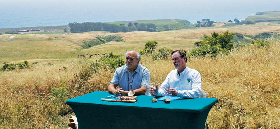
Valentin Lopez, chair of the Amah Mutsun tribe, at left, with Rick Cooper, field manager of the Bureau of Land Management’s Central Coast Field Office, after the two signed a memorandum of understanding between the Amah Mutsun Land Trust and the BLM that will facilitate the preservation and continuity of local Native heritage. Photo by Elizabeth Devitt.
Another land management collaboration is taking place north of San Francisco. In Petaluma, Kent Lightfoot supervises Peter Nelson, a UC Berkeley doctoral candidate in anthropology. Nelson is a member of the Federated Indians of Graton Rancheria in Sonoma County, and he’s working with his tribe and the Sonoma County Regional Parks Department to restore and manage Tolay Lake Regional Park.
“We are still generating baseline data with these studies,” said Hylkema, of the work in Quiroste Valley and two upcoming investigations at other sites along the Central Coast. “But we’re changing our way of looking at managing lands. Our ecologists are now thinking about managing for successions of plants and the biodiversity they support, instead of just fire reduction.”
Elizabeth Devitt covers open space for the Monitor.